Mi pare che la grande e dovuta attenzione dei mass media italiani alla tragedia dell’abbattimento dell’aereo civile Malaysia Airlines Boeing-777 dello scorso 17 luglio, con quasi 300 morti civili innocenti, abbia seguito la consueta “costante di decadimento” tipica della nostra informazione mainstream.
Cosa intendo? Facile. Se facciamo, per comodità, 100 la quantità di notizie il giorno dopo un evento internazionale anche clamoroso, essa diventa 10 il giorno successivo, 1 il giorno dopo ancora, e poi si avvicina allo zero: questo, indipendentemente dal fatto che su quell’evento ci siano nuovi clamorosi sviluppi. E allora, o sai l’inglese, il francese, lo spagnolo, e cerchi di seguire sulla stampa internazionale, oppure vai sui blog.
Ovviamente, la regola non si applica se l’evento diventa oggetto di una trasmissione con plastico di Bruno Vespa od assimilati. In questo caso, l’attenzione resta battente anche a babbo morto.
Bene. Due giorni fa la Russia ha presentato ufficialmente — in una pubblica e, come si dice, “partecipatissima”, conferenza stampa una sfilza di risultati di osservazioni radar e immagini satellitari che mi hanno letteralmente fatto saltare sulla sedia.
Il testo inglese è riportato in fondo a questo articolo. Ma vediamone la sostanza nella nostra amata lingua madre.
In sostanza, ci sono due fatti nuovi:
1) L’esercito ucraino aveva tre o quattro battaglioni di difesa aerea dotati di sistemi di Buk-M1 SAM schierati in prossimità di Donetsk il giorno dell’incidente. Questi missili erano in grado di colpire l’aereo civile. Altri missili terra-aria non ne avevano la possibilità, data l’altezza e la posizione dell’aereo. Le ricostruzioni americane basate sul trasferimento di missili terra-aria russi in territorio ucraino sono frutto di un video-bufala.
2) C’era un caccia dell’esercito ucraino a 3 km dal Boeing nel momento dell’abbattimento nel video della torre di controllo. Questo caccia — modello Su–25 — lo si vede muoversi verso l’alto verso il Boeing–777. La distanza tra i velivoli era di 3–5 km. Il Su–25 è armato con missili aria–aria R–60, in grado di agganciare un bersaglio a una distanza di 12 km, e distruggerlo definitivamente ad una distanza di 5 km. I russi chiedono: qual era la missione del velivolo da combattimento, che si trovava su rotte civili?
Capperi.
La conferenza stampa è stata tenuta da due funzionari di alto livello dell’esercito russo, il Capo di Stato Maggiore Andrey Kartopolov e il Comandante dell’aeronautica Igor Makushev. Hanno di fatto smontato le affermazioni di Kiev dimostrando che la responsabilità di quanto accaduto non sarebbe da attribuire alle milizie filorusse dell’Ucraina orientale bensì a una precisa azione militare dell’esercito ucraino.
Accidenti. Occorre verificare, che dite?
———————————
Andando più nel dettaglio, i russi hanno posto dieci domande agli ucraini ed ai loro alleati occidentali e statunitensi. Domande che attendono risposta, pubblicate da Russia Today:
1. Perché il volo MH17 ha lasciato il corridoio internazionale nel momento in cui sorvolava la città di Donetsk virando verso nord?
2. Questo cambio di percorso è stato dovuto a un errore della cabina di comando dell’aereo, oppure il pilota è stato tratto in errore perché ha seguito le indicazioni del controllori del traffico aereo di Dnepropetrovsk?
3. Perché l’esercito ucraino ha schierato un imponente sistema di difesa anti-aerea in quest’area dell’Ucraina dell’est se le milizie separatiste non hanno velivoli a loro disposizione?
4. Perché Kiev ha implementato il sistema missilistico Buk proprio nella zona controllata dalle milizie separatiste in cui è avvenuta la tragedia?
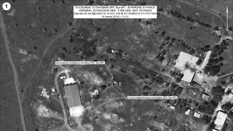
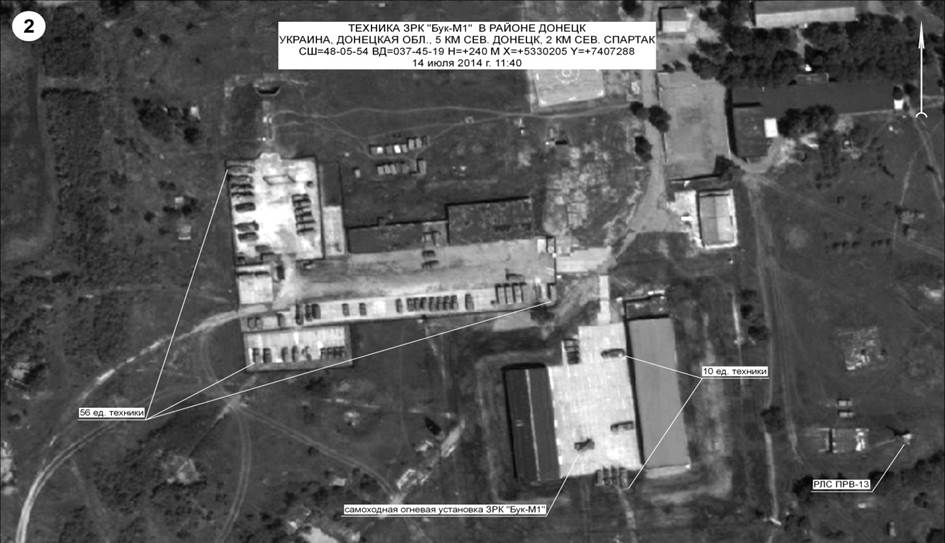
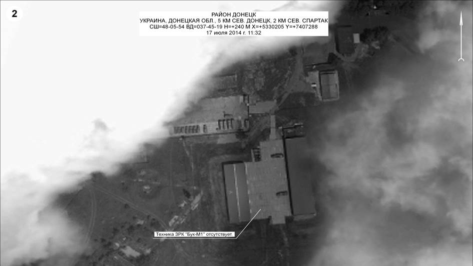
Ci sono foto satellitari delle unità di difesa aerea dell’Ucraina nella parte sud orientale del Paese. Le prime tre foto sono state scattate il 14 luglio. La prima mostra sistemi di lancio Buk situtati 8 km a nord ovest di Lugansk (un TELAR e due Tels). La seconda foto mostra radar situati 5 km a nord di Donetsk. Si possono vedere due TARs insieme ad altre attrezzature militari. La terza foto mostra sistemi di difesa aerea a nord di Donetsk (un sistema di lancio TELAR e circa 60 militari oltre a veicoli, tendoni e altre apparecchiature). Una foto della stessa area scattata il 17 luglio (il giorno dell’abbattimento dell’aereo), mostra che i sistemi di lancio non ci sono più.
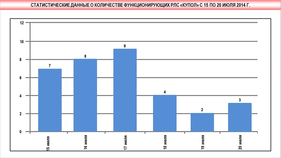
5. Perché il giorno dello schianto dell’aereo è stato registrato un aumento delle attività dei radar dell’esercito ucraino 9S18 Kupol-M1, componenti del sistema Buk, installati nell’area dell’abbattimento?
6. Perché quel giorno un aereo militare ucraino percorreva il corridoio internazionale riservato agli aerei civili?
C’erano tre aerei civili in quell’area in quel lasso di tempo: un volo Copenaghen-Singapore (17:17), un volo Parigi-Taipei (17:24) e il volo Amsterdam-Kuala Lumpur abbattuto. Ma appunto i sistemi di monitoraggio russi hanno registrato anche la presenza di un caccia dell’aeronautica ucraina, come detto sopra.
7. Perché un caccia militare ucraino volava nello stesso momento e nella stessa area attraversata da un aereo passeggeri?
8. Da dove proviene il lancio del missile? Da dove proviene il video diffuso dai media occidentali secondo cui il sistema Buk utilizzato sarebbe stato trasferito dal territorio russo in territorio ucraino?
Il video in questione è frutto di una montatura: è stato realizzato nella città di Krasnoarmeisk, come dimostra il cartellone che si vede sullo sfondo dove compare la pubblicità di una concessionaria di auto al civico 34 di Dnepropetrovsk Street. Krasnoarmeysk, come noto, è sotto il controllo dei militari ucraini dal 11 maggio. Non quindi dei separatisti.
9. Dimostrato che il video è stato realizzato in una parte di territorio ucraino controllato da Kiev, dove si troverebbe adesso il sistema Buk che ha lanciato il missile? Quando è stata l’ultima volta che un missile è stato lanciato da questo sistema?
10. Perché i funzionari del governo americano non hanno ancora fornito le prove che dimostrerebbero che l’aereo è stato abbattuto da un missile lanciato dalle milizie separatiste filorusse?
I funzionari americani affermano di avere foto satellitari che provano che l’aereo di linea della Malesia è stato abbattuto da un missile lanciato dalle milizie filorusse. Ma nessuno ha visto finora queste fotografie.
—————————-
Mi sa che a queste domande occorrerebbe dare:
- Visibilità sui media occidentali (speranze scarse)
- Risposte (speranze altrettanto scarse).
—————————–
Ecco il testo completo in inglese della Conferenza Stampa, con le immagini satellitari. Poi, sotto, il video della conferenza, che è in russo, ma con traduzione sequenziale e sottotitoli in inglese.
The Main Operations Directorate – the Deputy Chief of the General Staff of the Armed Forces of the Russian Federation Lieutenant-General A.V.Kartapolov
Dear representatives of mass media!
Ladies and gentlemen!
After the Malaysia Airlines Boeing-777 accident on July 17, following the international airway Amsterdam — Kuala Lumpur, we can find quantity of conflicted information. In this case the Russian Federation Ministry of Defense considers necessary to submit information having at the General Staff disposal. On the scheme you can see the international airway. The Boeing-777 was supposed to fly on this airway. Draw your attention to the fact that the aircraft followed inside the specified air-corridor to Donetsk, then it deviated from the route to north. Meanwhile the maximum distance from the left border of the air-corridor was 14 kilometers.
Then we can see that the Boeing-777 turned back to the borders of the specified air-corridor. Nevertheless Malaysian aircrew didn’t succeed the maneuver. At 17.20 we entered the event of the aircraft rate reduction, at 17.23 the aircraft’s point blinked off on the radar. Why did the aircraft cross the border of the air-corridor? Was it the navigation mistake, or the aircrew followed the Dnepropetrovsk ground control orders? We will find the answers after “black boxes” and communication decoding. According to our information on the day of the accident the Ukrainian Armed Forces deployed 3 to 4 artillery battalions of Buk-M1 missile system not far from Donetsk. The system allows hitting the targets on the distance up to 35 kilometers and on the altitude to 22 kilometers. Why did the Ukrainian Armed Forces deploy these air defense units in the Donetsk region?As we know militants don’t have aircrafts. On the scheme we can see that both projected impact point and the airway are inside the air defense battle zone of the Ukrainian Armed Forces’ Buk-M1 missile system. We have satellite photos of the Ukrainian Air Defense systems deployed in the South-East of the country.
The first 3 photos are dated July 14, 2014:
On the first photo you can see the Buk missile systems deployed 8 kilometers north-west to Luhansk. On the photo you can see clearly a self-propelled launch system and 2 loading vehicles.
On the second photo you can see radars deployed 5 kilometers north to Donetsk. We can see 2 radars, different equipment and facilities.
On the third photo we can see air defense equipment deployed north to Donetsk. You can see clearly self-propelled launch system with turned launch shoe and near 60 units of military and special-proposed equipment, mounted defilades and facilities.
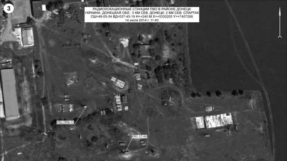
Here you can see a photo of the same area on July 17. Draw your attention that the antiaircraft system is absent on this photo.
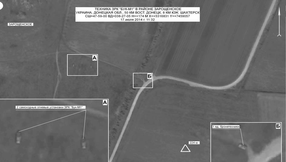
On the fifth photo we can see Buk-M1 artillery battalion deployed 50 kilometers east to Donetsk and 8 kilometers south to Shakhtarsk. We can answer: why the battalion was deployed near to the territory controlled by militants just before the accident?
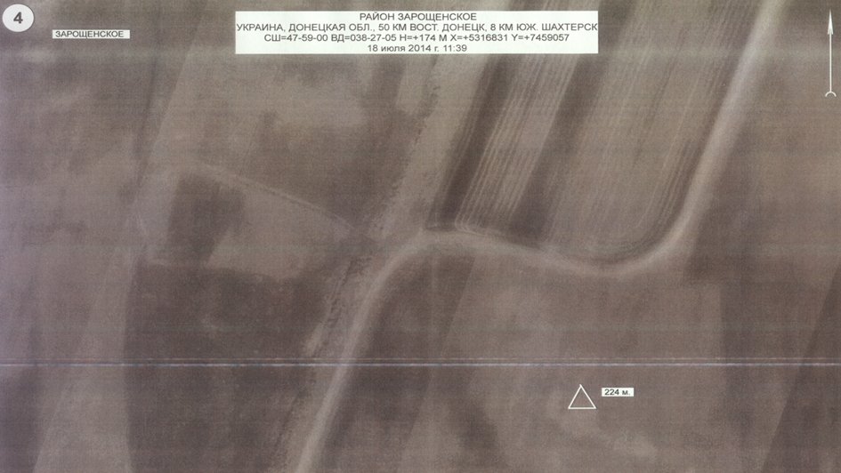
On the photo of same area dated July 18 we can see that the battery left the occupied position. Besides it, on July 17 we detected increased activity of Ukrainian radars 9S18 Kupol-M1 of the Buk missile system.
On the photo you can see that 7 radars worked on July 15, 8 radars on July 16, and 9 radars on July 17. Since July 18 there are only 2–3 radars per twenty-four hours. We shall find out the reasons for the events.
I want to expose air situation in Donetsk area that day. On the picture you can see information of objective control since 17.10 to 17.30 Moscow time.
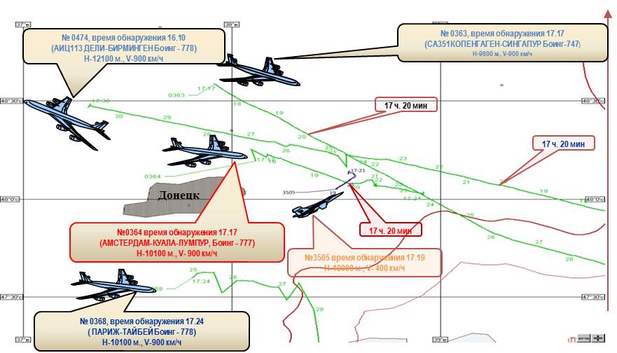
At that time there were 3 civilian aircrafts:
- Flight from Copenhagen to Singapore at 17.17;
- Flight from Paris to Taipei at 17.24
- Flight from Amsterdam to Kuala Lumpur.
Besides it, Russian system of air control detected the Ukrainian Air Force aircraft, purposed Su-25, moving upwards toward to the Malaysian Boeing-777. The distance between aircrafts was 3–5 kilometers.
Su-25 can gain an altitude of 10000 meters for a short time. It is armed with air-to-air missile R-60 able to lock-on and destroy target at a distance of 12 kilometers, and destroy it definitely at a distance of 5 kilometers. What was the mission of the combat aircraft on the airway of civilian aircrafts almost at the same time and same altitude with the civilian craft? We want to have this question answered.
The video of the Rostov Aerial Center of the Joint Air Traffic Management System can corroborate the information. The Chief of Staff of the Air Force Lieutenant-General Igor Makushev will comment the video.
Commentary of the Chief of Staff of the Air Force of the Russian Federation Lieutenant-General I.Y.Makushev
Dear Ladies and Gentlemen!
Today the Aircraft Air Traffic control has acquired some objective control materials from the Rostov Aerial Center of the Joint Air Traffic Management System. The video presents the air control information on air situation in the region of Donetsk in the period from 17.19 P.M. to 17.25 P.M. Moscow time on July 17, 2014. In the upper left corner there is a Boeing-772 mark, following the route from Copenhagen to Singapore. Under this point there is another aircraft, it is Boeing-777 mark, which is on his way from Amsterdam to Kuala Lumpur. And on its right there is a Boeing-778 mark making its way from Delhi to Birmingham. All the three aircraft have been steadily monitored by the three radar stations of the air traffic control of the Ministry of Defense of the Russian Federation. Boeing-777 is moving towards the Russian Federation state boundary and is to cross it in the point of «TONAK». An air traffic control officer has been controlling the aircraft flight and keeps on enquiring its flight variables to compare them with the given ones. At 17.20 P.M. at the distance of 51 kilometers from the Russian Federation state boundary and the azimuth of 300 degrees the aircraft started to lose its speed obstructively which is quite distinctively to be seen on the table of the aircraft characteristics. At 17.21 35 seconds P.M. with the aircraft speed of 200 km/h at the point of the Boeing crash there is a new mark of the aircraft to be seen. The aircraft was steadily monitored by radar stations of Ust-Donetsk and Butirinskoe during 4 minutes period. Air control officer having enquired the characteristics of newly appeared aircraft couldn’t possibly get them because it is in all likelihood that the aircraft had no secondary deduction system amounted on it, which is put typically for military aircraft. The early detection of this aircraft appeared to be quite impossible because the air situation control is usually performed by radars working in a standby mode which detection possibilities at the given distance are over 5000 m altitude.
The detection of the aircraft turned out to be possible as the aircraft ascend it.
The further aircraft flight variables changes on its route testified the fact that it is now flying in the area of Boeing crash and is monitoring the situation. Earlier the Ukrainian officials reported that on the day of the Boeing-777 accident there were no military aircraft available in the region. So, as you can see, it is not appeared to be true. Thank you for your attention.
Ladies and Gentlemen, we also have some questions to our US partners.According to the statement of the US representatives they have some pictures from the space supporting that missile launching was made by the militants.But nobody has seen these pictures.
According to our dates from 17:06 till 17:21 Moscow time on the July 17 over the South-Eastern territory of Ukraine flew US space satellite. This is a special device of the experimental space system designed to detect and track various missiles launches. If the US party has photos made by the satellite, please let us ask them to show the world’s community for further investigation.
Is it coincidence or not? However the time of the Malaysian Boeing-777 accident and the time of the observation done by the satellite over the Ukrainian territory are the same. To conclude it I would like to mention that all the concrete information is based on the objective and reliable dates of the different Russian equipment in contrast to the accusations of the US against us made without any evidence.The good example of such fact is that some mass media showed transportation of the Buk-M1 missile system from Ukrainian to Russian territory.We can clearly see that its frame-up. These pictures were made in the city of Krasnoarmeisk that is confirmed by a banner situated close to the road. This banner has an address of the car shop situated at the Dnepropetrovskaya, 34. Since May 11 the Krasnoarmeysk city is under control of the Ukrainian Armed Forces. That is why we have some questions. What kind of launching system is it? Where is it transported? Where is it now? Why is it unloaded completely? What was the last time it launched missiles? To end my speech I would like to emphasize that the Russian Federation did not deliver to the militants any Buk-M1 missiles systems and other equipment. All the dates prepared by the Ministry of Defense of the Russian Federation will be transmitted today to the experts of the European countries and Malaysia. I hope these dates will help to make the reliable investigation of the tragedy that happened on the July 17 over Donetsk. The Ministry of Defense will continue to inform you about the newly revealed facts connected with the air disaster of Malaysian Boeing-777.
Thank you for your attention.
Reference: official web-site of the Ministry of Defence of the Russian Federation
*****************************
Guardate voi stessi il video completo
* dal suo blog su ilmanifesto.it
- © Riproduzione possibile DIETRO ESPLICITO CONSENSO della REDAZIONE di CONTROPIANO
Ultima modifica: stampa